Recently Viewed ›
Recently Downloaded 
Close x

Here are some fantastic child-friendly facts about the London Underground that you can use to engage your students:
 london
underground map
london map
london underground
london landmarks
london activities
all about london
underground
train map
map of london
maps eyfs
trains
maps
capital cities in uk
liburan ke london
life in the uk
london
underground map
london map
london underground
london landmarks
london activities
all about london
underground
train map
map of london
maps eyfs
trains
maps
capital cities in uk
liburan ke london
life in the uk
Working with maps and keys
I would have loved to use this, but the map is incomplete.
Hi JasonRE,
Thanks for getting in touch! We're just looking into this for you and we'll get back to you as soon as we can! :)
 Alison.C@Twinkl 7 years ago
Hi,
Can I please request an editable version of this map, I'd like to replace some of the station names with the names of the children in my class.
Thanks, Anna
Hi missachaudhry,
I'll see what we can do for you! Thanks for commenting :)
 Lucy.B@Twinkl 7 years ago
Hi there missachaudhry,
This has been completed now and we have emailed the new resource to you! It will also be available on the website within 48 hours, and you can find it either as a main resource, or under 'Alternative versions' above. I hope you find it useful!
 joe.hart@twinkl.co.uk 7 years ago
Here are some fantastic child-friendly facts about the London Underground that you can use to engage your students:
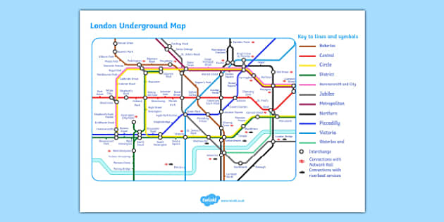
This handy resource features the London Underground Map, perfect for upper Key Stage Geography classes! This city is the capital of the UK and a major city to learn about what goes on. What better way to get familiar with the different places in London than looking at the London Underground Map? This will give your students first-hand experience in understanding the different underground lines and how to get from one place to another, what tube changes would be needed etc. This sheet is perfect to pair with the London Underground Routes Writing Frames.
The London Underground is the biggest rapid transit system in the UK. It opened in January 1863 and now has 11 lines! Including Bakerloo, Central, Circle, district, Hammersmith and city, Jubilee, Metropolitan, Northern, Piccadilly, Victoria and Waterloo and City. The London Underground Map shows all of these lines in different colours, as well as the different parts of the city, and key symbols to help out passengers.
 Home
Home  Membership
  Customer Support
  Create
  Blog
Blog