- India
- International
Sunday, May 05, 2024
Journalism of Courage
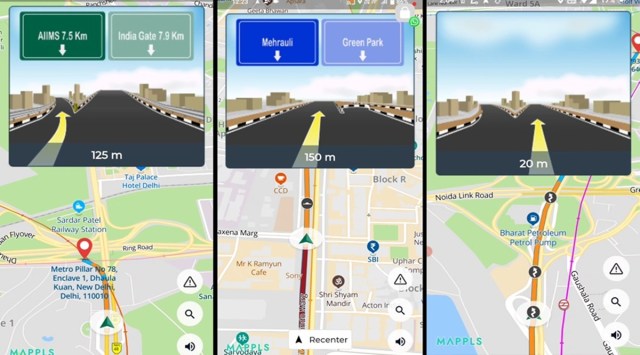 Mappls is one of the most popular navigation apps in India. (Image Source: MapMyIndia)
 MapMyIndia, one of the most popular digital map apps in India, announced the launch of a new feature called ‘Junction View’ for its Mappls app. The new feature helps users navigate safely through intersections, flyovers, and road forks by providing a photo-realistic 3D view of the upcoming junction.
The ‘Junction View’ feature has pictures tens of thousands of photos of different junctions in its database and is currently available in several major cities across India, including Delhi, Noida, Kolkata, Gurgaon, Pune, Mumbai, Hyderabad, Bangalore, Ludhiana, Chennai, and Lucknow.
By providing drivers with a preview of the next junction, including marked lanes and the entry and exit points of flyovers, Mappls aims to improve safety and make navigating through busy intersections easier and more efficient. This is really useful since other popular navigation apps like Waze and Google Maps do not offer similar functionality.
Designed especially for India, Mappls offers features like precise doorstep navigation, voice-guided directions, updates on local issues, easy sharing of a digital address and many more. It is currently available for download on Android and iOS devices.
CISCE has announced the date and time for the release of the ICSE Class 10 and 12 results 2024. The results will be available on May 6 at 11 am on the official website. The exams were conducted in a pen-and-paper format. Last year, the overall pass percentage for Class 12 was 96.93 per cent, with girls outperforming boys.